


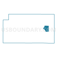
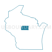
RINGLE - T 1 Voting District, Marathon County, Wisconsin
About
Outline

Summary
| Unique Area Identifier | 694834 |
| Name | RINGLE - T 1 Voting District |
| County | Marathon County |
| State | Wisconsin |
| Area (square miles) | 24.94 |
| Land Area (square miles) | 24.92 |
| Water Area (square miles) | 0.01 |
| % of Land Area | 99.95 |
| % of Water Area | 0.05 |
| Latitude of the Internal Point | 44.90335050 |
| Longtitude of the Internal Point | -89.39046870 |
Maps

Graphs
Select a template below for downloading or customizing gragh for RINGLE - T 1 Voting District, Marathon County, Wisconsin


Neighbors
Neighoring Voting District (by Name) Neighboring Voting District on the Map
- EASTON - T 1 Voting District, Marathon County, WI
- EASTON - T 2 Voting District, Marathon County, WI
- ELDERON - T 1 Voting District, Marathon County, WI
- Hatley - V 1 Voting District, Marathon County, WI
- NORRIE - T 1 Voting District, Marathon County, WI
- PLOVER - T 1 Voting District, Marathon County, WI
- REID - T 1 Voting District, Marathon County, WI
- REID - T 2 Voting District, Marathon County, WI
- RINGLE - T 2 Voting District, Marathon County, WI
Top 10 Neighboring County Subdivision (by Population) Neighboring County Subdivision on the Map
- Ringle town, Marathon County, WI (1,711)
- Reid town, Marathon County, WI (1,215)
- Easton town, Marathon County, WI (1,111)
- Norrie town, Marathon County, WI (976)
- Plover town, Marathon County, WI (689)
- Elderon town, Marathon County, WI (606)
- Hatley village, Marathon County, WI (574)
Top 10 Neighboring Place (by Population) Neighboring Place on the Map
Top 10 Neighboring Unified School District (by Population) Neighboring Unified School District on the Map
Top 10 Neighboring State Legislative District Lower Chamber (by Population) Neighboring State Legislative District Lower Chamber on the Map
- Assembly District 86, WI (59,763)
- Assembly District 85, WI (54,840)
- Assembly District 36, WI (50,804)